What Do We Know About the Nazca Lines? One day in 1926, Toribio Mejía Xesspe (say: ZESS-pay) took a hike in the hills near the town of Nazca in southern Peru. From the top of a hill, Mejía Xesspe gazed across the landscape below him, called the Nazca Pampa: a flat, featureless desert plateau around eighty-five square miles in size. Little grows on this barren land, littered with pebbles and rocks.
The pampa is situated high up, around 1,500 feet above sea level. To the east lie the mighty Andes Mountains, and to the west, the Pacific Ocean. On the southern edge of the pampa is the Nazca River; to the north, the Ingenio River. The rivers bring some water to the valleys below them, but little water ever reaches the elevated pampa. In fact, it is one of the driest places on Earth. This is because the Andes Mountains block the clouds that carry water toward the coast. As a result, less than one millimeter of rain falls on the pampa each year.
To Mejía Xesspe, who was an archaeologist (a person who analyzes artifacts to study human history), the pampa seemed like a giant wasteland. But when he looked more carefully, he could see something strange crisscrossing the surface of the flat land below him. It looked like lines. Some of the lines crossed others; some stretched hundreds of feet into the distance. Some seemed to form shapes, such as triangles and rectangles. Others were harder to make out. The pampa looked a bit like a geometry teacher’s chalkboard after a busy week of lessons.
Intrigued, Mejía Xesspe walked down to the pampa to take a closer look. Here, he found the lines were more like etchings on the land’s surface. The dark desert pebbles had been moved away to reveal the pale sand beneath.
Some of the lines were less than thirty inches wide, but others were as wide as six feet. Their straight edges were too precise to have been made by the flow of water. There were no rivers on the pampa anyway. But this also meant there had been nothing to wash the lines away. They were probably very old.
Finding the lines had surprised Mejía Xesspe. He felt certain that they had been made by people. But he didn’t make a big deal about them. At the time, he was making other important discoveries with Julio C. Tello, a famous archaeologist often called the Father of Peruvian Archaeology.
To this day, no one has been able to solve the ancient mystery of what became known as the Nazca Lines.
Chapter 1 Patterns on the Pampa Located on the west coast of South America, the country of Peru has a variety of landscapes that include mountains, deserts, beaches, and rain forests. It is comprised of coastal plains in the west, high rugged mountains in the center, and lowland jungle in the east. The Amazon Rain Forest—the largest in South America—covers more than half of Peru. Stretching from north to south are the Andes Mountains. The Andes are so high (averaging between 13,000 and 22,000 feet above sea level) that they can be seen from Peru’s Pacific Coast beaches, fifty miles to the west. Peru’s west coast is made up of a narrow strip of desert around 1,555 miles long. It is here that ancient cultures such as the Paracas and Nazca used to live. Later, the Inca Empire took over and built large cities and temples.
The Paracas people were an ancient Peruvian culture who lived between 750 BCE and 200 CE. They existed before the Nazca, but inhabited parts of the same area in Peru’s south. They were also a big influence on the Nazca people. Both cultures were famous for their ceramics (pottery), textiles (fabric), and for the way they buried their dead. This included placing the bodies in a crouching position and wrapping them in layers of cloth. Known as “mummy bundles,” the bodies were then buried together in an underground chamber.
We know about the Paracas because of Toribio Mejía Xesspe and Julio Tello, who investigated the remains of the culture in the 1920s. In 1929, Tello unearthed a large burial site that contained 429 mummy bundles. This amazing find included ceramics, textiles, and jewels, which helped them to understand the Paracas culture.
The Inca The Inca were a famous South American civilization who built their capital, Cuzco, in what is now Peru. Between the thirteenth and fifteenth centuries, the Inca conquered a vast tract of land that extended from present--day Ecuador to Chile. To control this empire, the Inca kings built a vast network of roads, fortifications, cities, and temples. Their twelve million subjects worshipped the Inca gods, such as the rain god, Apu Illapu. However, just as the Inca Empire reached its peak in 1532, it was overthrown by conquistadors (conquerors) from Spain. Afterward, whole Inca cities were abandoned and forgotten. Like the Nazca, the Paracas did not have a written language. This means that everything we know about them comes from the objects they left behind. While archaeologists carefully preserve their finds for study, there are people who are simply interested in selling ancient objects to make a profit.
Tello and Mejía Xesspe’s important finds at Paracas may explain why Mejía Xesspe did not fully investigate the lines on the Nazca Pampa. However, Mejía Xesspe did talk about the Nazca Lines in a 1939 conference in Lima, Peru’s capital. Here, he explained that he thought they were “religious roads,” which may have been used for processions. He also wrote a paper about them, although he did not study them further himself. Neither Mejía Xesspe’s talk nor his paper seemed to generate much interest.
One person who may have attended Mejía Xesspe’s talk, however, was American historian Paul Kosok. At that time, Kosok was in Lima, studying ancient cultures. In 1941, Kosok traveled to the Nazca Pampa to look at the lines himself. They immediately grabbed his attention. Kosok and his wife, Rose, then moved to Nazca to study them further. Their work marked a turning point in learning why the Nazca Lines may have been made.
The Kosoks found that actually making the lines had been quite simple. It involved moving the darker stones and pebbles to the sides while creating a shallow trench in the lighter sand underneath. The stones and pebbles then formed a border on either side of the trench. These borders ranged in size from one inch to three feet high. Other stones were removed and placed in piles.
Tomb Robbers Tomb robbers, or looters, have been stealing objects left by the Nazca for many centuries. These include Nazca ceramics, which collectors have always found desirable. Even today, looters visit sites recently uncovered by archaeologists to see if there are any ancient items worth stealing. These rare and valuable finds are then illegally sold or traded. During their raids on ancient Nazca sites, careless tomb robbers have left objects they did not want strewn across the pampa, including Nazca textiles and bones from burial chambers. Bones and skulls can still be seen on the desert surface today, bleached bright white by the sunlight. The Kosoks believed that the straight lines were made using simple surveying tools, probably wooden stakes and string, to provide a guide for carving them. Not all the lines were straight: some had curves, spirals, and zigzag shapes. No one is exactly sure how this was done.
The color difference between the light sand of the dug-out line and the darker rocks covering the rest of the pampa made it stand out. From nearby hills, people would have been able to see parts of these images. However, the Kosoks found some of the designs to be massive. Some were hundreds of feet across! This puzzled the couple. There would be no way of seeing these entire images from the hill. The only way to properly view it was from high above it, in the air.
For the Kosoks, this raised an important question. It is one that has confused and divided archaeologists ever since.
In 1941, airplanes were still a relatively new invention. The Wright brothers made the first powered flight in 1903, but jet airplanes did not come into use until 1939. Interestingly, some planes flying over the Nazca Pampa had reported seeing lines on the ground even before the Kosoks arrived. But the Nazca themselves did not have planes, of course. So why then had the Nazca made patterns they would never be able to see?
To explore this mystery, the Kosoks hired a plane and took to the air. Even from this height, they found the lines difficult to see clearly. Over the centuries, they had become faint. This was because wind had blown small stones across some of them and covered the paler ground underneath. To make out particular shapes, the Kosoks took aerial photos from the plane and then walked along the ground taking exact measurements.
As they walked, the Kosoks realized that most of the designs ran in a continuous line. They could start in one place, walk around the entire outline of an image, and end up in the same place again. Were these pathways made to walk around? The Kosoks also often found broken pieces of pottery by the sides of the lines. The Nazca were famous for their ceramics, but why were pieces left here? Had the pottery been abandoned by the Nazca or by looters?
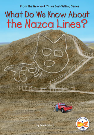
Then the Kosoks discovered something even more startling. One set of lines was not in a shape or a pattern, but a picture. It had been created in the shape of a bird. This was the first geoglyph to be discovered. But it would not be the last.
Copyright © 2024 by Penguin Random House LLC. All rights reserved. No part of this excerpt may be reproduced or reprinted without permission in writing from the publisher.